Schiaparelli, the Entry, Descent and Landing Demonstrator Module of the joint ESA/Roscosmos ExoMars 2016 mission, will target the Meridiani Planum region for its October landing, as seen in this mosaic created from Mars Express images.

This context image shows Meridiani Planum on Mars, including the planned landing site of Schiaparelli, the ExoMars Entry, Descent and Landing Demonstrator Module, which will touch down on the Red Planet on 19 October 2016. The landing ellipse lies within the region outlined by the inner white box, close to Endeavour crater. See the associated image release for details. This region was imaged during Mars Express orbits 2064, 2075, 2086, 8423, corresponding to taken on 23, 26 and 29 August 2005, and 1 August 2010 respectively. Image credit: NASA MGS MOLA Science Team
The landing ellipse, measuring 100 x 15 km, is located close to the equator, in the southern highlands of Mars. The region was chosen based on its relatively flat and smooth characteristics, as indicated in the topography map, in order to satisfy landing safety requirements for Schiaparelli.
NASA’s Opportunity rover also landed within this ellipse near Endurance crater in Meridiani Planum, in 2004, and has been exploring the 22 km-wide Endeavour crater for the last five years. Endeavour lies just outside the south-eastern extent of Schiaparelli’s landing ellipse.
The region has also been well studied from orbit and is shown to host clay sediments and sulphates that were likely formed in the presence of water. Indeed, a number of water-carved channels are also clearly visible, in particular in the southern portion of the image.

The colour-coded topographic view shows relative heights and depths of terrain in the Meridiani Planum region on Mars. Red and white represent the highest terrain, and blues and purples show lower terrain such as the interiors of craters (see key). The ellipse marked on the map outlines the target landing area for Schiaparelli, the ExoMars Entry, Descent and Landing Demonstrator Module. The site was chosen based on its relatively flat and smooth characteristics, in order to adhere to landing safety requirements. Endeavour crater lies immediately to the south east of the landing ellipse. The image is based on a digital terrain model of the region, from which the topography of the landscape can be derived. The view comprises four images taken by the High Resolution Stereo Camera on Mars Express on 23, 26and 29 August 2005, and 1 August 2010, and covers a region 352.5°–356.5°E and 4.5°S–0.5°N. Image credit: ESA/DLR/FU Berlin, CC BY-SA 3.0 IGO
Dune fields are seen inside a number of the craters in the region, and along with the dark deposits surrounding them, are likely shaped by wind and dust storms.
Although Schiaparelli’s main task is to demonstrate technologies needed to safely land on Mars, its small suite of scientific instruments will also record the wind speed, humidity, pressure and temperature at its landing site.
It will also obtain the first measurements of electric fields on the surface of Mars that, combined with measurements of the concentration of atmospheric dust, will provide new insights into the role of electric forces in dust lifting, the trigger for dust storms.

This perspective view in Meridiani Planum was generated from the high-resolution stereo camera on ESA’s Mars Express. It shows a relatively flat and smooth foreground, which includes the landing ellipse of the ExoMars Entry, Descent and Landing Demonstrator Module. Endeavour Crater, the current home to NASA’s Opportunity Rover, is in the background, while the crater in the foreground is known as Bopolu. Endeavour is about 22 km across, while Bopolu is 19 km wide. Surrounding Bopolu is the distinct pattern of crater ejecta – the debris thrown out from the surface during the impact event that formed the crater. Image credit: ESA/DLR/FU Berlin, CC BY-SA 3.0 IGO
Schiaparelli is riding to Mars on board the ExoMars Trace Gas Orbiter. The mission launched on a Proton rocket from Baikonur on 14 March, and is on course for a 19 October rendezvous with the Red Planet.
Schiaparelli will separate from its mothership on 16 October; three days later, it will use a combination of a heat shield, a parachute, a propulsion system and a crushable structure to slow down during its six-minute descent to the surface of Mars.

This perspective view in Meridiani Planum was generated from the high-resolution stereo camera on ESA’s Mars Express. The Entry, Descent and Landing Demonstrator Module of ESA’s ExoMars 2016 mission will target a landing site within the ellipse marked on the left hand side of the image. The ellipse extends close to Endeavour crater in the background, where NASA’s Opportunity rover is currently exploring. This oblique view also affords a detailed look at the 19 km-wide Bopolu crater in the foreground, and its ejecta blanket – the debris thrown out from the surface during the impact event that formed the crater. Image credit: ESA/DLR/FU Berlin, CC BY-SA 3.0 IGO
ESA’s Mars Express, which has been in orbit at the Red Planet since 2003, is among the fleet of orbiters that will act as a data relay during Schiaparelli’s short battery-powered mission on the surface.
Images acquired with the Mars Express High Resolution Stereo Camera on 23, 26 and 29 August 2005, and 1 August 2010, were used to compile the four-image colour mosaic featured in this release.
Top image:The landing ellipse of Schiaparelli, the ExoMars Entry, Descent and Landing Demonstrator Module, is shown in this four-image High Resolution Stereo Camera mosaic of Meridiani Planum compiled from Mars Express data.
The mosaic consists of four orbit strips, 2064, 2075, 2086, 8423, taken on 23, 26 and 29 August 2005, and 1 August 2010 respectively, and covers a region 352.5°–356.5°E and 4.5°S–0.5°N. It was created using data from the nadir channel, the field of view of which is aligned perpendicular to the surface of Mars, and the colour channels of the HRSC.
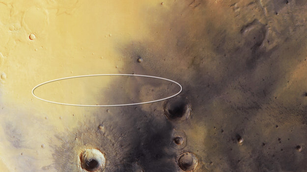
To the north, smooth, flat plains are observed, with faint traces of ancient craters. Schiaparelli, the ExoMars Entry, Descent, and Landing Demonstrator Module, will target a flat region within the smooth plains, to the west of 22 km-wide Endeavour crater, close to the centre of this image.
Below and to the left is 19 km-wide Bopolu crater, which lies within the much larger Miyamoto crater. Parts of the northern rim of Miyamoto have since been buried, leaving only the southern portions clearly visible.
In the south and southeastern portions of the image in particular, a number of channels can be identified, carved by water flow in Mars’ past.
Image credit: ESA/DLR/FU Berlin, CC BY-SA 3.0 IGO
Filed under: Mars