Scientists may be closer to solving the mystery of how Mars changed from a world with surface water billions of years ago to the arid Red Planet of today.
A new analysis of the largest known deposit of carbonate minerals on Mars suggests that the original Martian atmosphere may have already lost most of its carbon dioxide by the era of valley network formation.
“The biggest carbonate deposit on Mars has, at most, twice as much carbon in it as the current Mars atmosphere,” said Bethany Ehlmann of the California Institute of Technology and NASA Jet Propulsion Laboratory, both in Pasadena. “Even if you combined all known carbon reservoirs together, it is still nowhere near enough to sequester the thick atmosphere that has been proposed for the time when there were rivers flowing on the Martian surface.”
Carbon dioxide makes up most of the Martian atmosphere. That gas can be pulled out of the air and sequestered or pulled into the ground by chemical reactions with rocks to form carbonate minerals. Years before the series of successful Mars missions, many scientists expected to find large Martian deposits of carbonates holding much of the carbon from the planet’s original atmosphere. Instead, these missions have found low concentrations of carbonate distributed widely, and only a few concentrated deposits. By far the largest known carbonate-rich deposit on Mars covers an area at least the size of Delaware, and maybe as large as Arizona, in a region called Nili Fossae.
Christopher Edwards, a former Caltech researcher now with the U.S. Geological Survey in Flagstaff, Arizona, and Ehlmann reported the findings and analysis in a paper posted online by the journal Geology. Their estimate of how much carbon is locked into the Nili Fossae carbonate deposit uses observations from numerous Mars missions, including the Thermal Emission Spectrometer (TES) on NASA’s Mars Global Surveyor orbiter, the mineral-mapping Compact Reconnaissance Imaging Spectrometer for Mars (CRISM) and two telescopic cameras on NASA’s Mars Reconnaissance Orbiter, and the Thermal Emission Imaging System (THEMIS) on NASA’s Mars Odyssey orbiter.
Edwards and Ehlmann compare their tally of sequestered carbon at Nili Fossae to what would be needed to account for an early Mars atmosphere dense enough to sustain surface waters during the period when flowing rivers left their mark by cutting extensive river-valley networks. By their estimate, it would require more than 35 carbonate deposits the size of the one examined at Nili Fossae. They deem it unlikely that so many large deposits have been overlooked in numerous detailed orbiter surveys of the planet. While deposits from an even earlier time in Mars history could be deeper and better hidden, they don’t help solve the thin-atmosphere conundrum at the time the river-cut valleys formed.
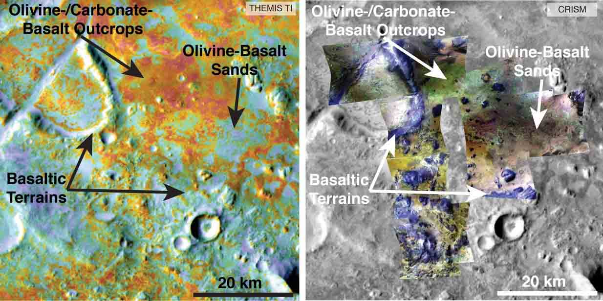
Researchers estimating the amount of carbon held in the ground at the largest known carbonate-containing deposit on Mars utilized data from three different NASA Mars orbiters.
Each image in this pair covers the same area about 36 miles (58 kilometers) wide in the Nili Fossae plains region of Mars’ northern hemisphere. The tally of carbon content in the rocks of this region is a key piece in solving a puzzle of how the Martian atmosphere has changed over time. Carbon dioxide from the atmosphere on early Mars reacted with surface rocks to form carbonate, thinning the atmosphere.
The image on the left presents data from the Thermal Emission Imaging System (THEMIS) instrument on NASA’s Mars Odyssey orbiter. The color coding indicates thermal inertia — the property of how quickly a surface material heats up or cools off. Sand, for example (blue hues), cools off quicker after sundown than bedrock (red hues) does.
The color coding in the image on the right presents data from the Compact Reconnaissance Imaging Spectrometer for Mars (CRISM) instrument on NASA’s Mars Reconnaissance Orbiter. From the brightness at many different wavelengths, CRISM data can indicate what minerals are present on the surface. In the color coding used here, green hues are consistent with carbonate-bearing materials, while brown or yellow hues are olivine-bearing sands and locations with purple hues are basaltic in composition. The gray scale base map is a mosaic of daytime THEMIS infrared images.
Annotations point to areas with different surface compositions. The scale bar indicates 20 kilometers (12.4 miles).
In addition to data from THEMIS and CRISM, researchers estimating the amount of carbon in rocks of the Nili Fossae plains used data from the Thermal Emission Spectrometer instrument on NASA’s Mars Global Surveyor orbiter, which operated from 1997 to 2006, and from two telescopic cameras on Mars Reconnaissance Orbiter: the Context Camera and the High Resolution Imaging Science Experiment.
The modern Martian atmosphere is too tenuous for liquid water to persist on the surface. A denser atmosphere on ancient Mars could have kept water from immediately evaporating. It could also have allowed parts of the planet to be warm enough to keep liquid water from freezing. But if the atmosphere was once thicker, what happened to it? One possible explanation is that Mars did have a much denser atmosphere during its flowing-rivers period, and then lost most of it to outer space from the top of the atmosphere, rather than by sequestration in minerals.
“Maybe the atmosphere wasn’t so thick by the time of valley network formation,” Edwards said. “Instead of Mars that was wet and warm, maybe it was cold and wet with an atmosphere that had already thinned. How warm would it need to have been for the valleys to form? Not very. In most locations, you could have had snow and ice instead of rain. You just have to nudge above the freezing point to get water to thaw and flow occasionally, and that doesn’t require very much atmosphere.”
NASA’s Curiosity Mars rover mission has found evidence of ancient top-of-atmosphere loss, based on the modern Mars atmosphere’s ratio of heavier carbon to lighter carbon. Uncertainty remains about how much of that loss occurred before the period of valley formation; much may have happened earlier. NASA’s MAVEN orbiter, examining the outer atmosphere of Mars since late 2014, may help reduce that uncertainty.
Arizona State University, Tempe, provided the TES and THEMIS instruments. The Johns Hopkins University Applied Physics Laboratory, Laurel, Maryland., provided CRISM. JPL, a division of Caltech, manages the Mars Reconnaissance Orbiter and Mars Odyssey project for NASA’s Science Mission Directorate, Washington, and managed the Mars Global Surveyor project through its nine years of orbiter operations at Mars. Lockheed Martin Space Systems in Denver built the three orbiters.
More information about the Mars Reconnaissance Orbiter mission.
More information about the Mars Odyssey mission.
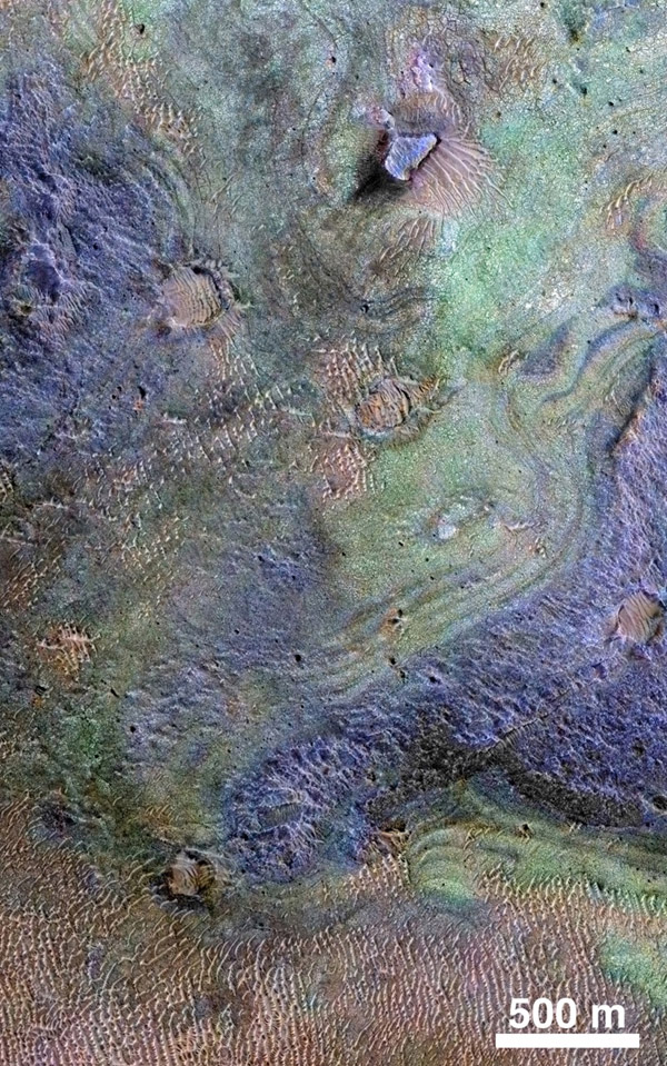
Top image: This view combines information from two instruments on NASA’s Mars Reconnaissance Orbiter to map color-coded composition over the shape of the ground in a small portion of the Nili Fossae plains region of Mars’ northern hemisphere.
This site is part of the largest known carbonate-rich deposit on Mars. In the color coding used for this map, green indicates a carbonate-rich composition, brown indicates olivine-rich sands, and purple indicates basaltic composition.
Carbon dioxide from the atmosphere on early Mars reacted with surface rocks to form carbonate, thinning the atmosphere by sequestering the carbon in the rocks.
An analysis of the amount of carbon contained in Nili Fossae plains estimated the total at no more than twice the amount of carbon in the modern atmosphere of Mars, which is mostly carbon dioxide. That is much more than in all other known carbonate on Mars, but far short of enough to explain how Mars could have had a thick enough atmosphere to keep surface water from freezing during a period when rivers were cutting extensive valley networks on the Red Planet. Other possible explanations for the change from an era with rivers to dry modern Mars are being investigated.
This image covers an area approximately 1.4 miles (2.3 kilometers) wide. A scale bar indicates 500 meters (1,640 feet). The full extent of the carbonate-containing deposit in the region is at least as large as Delaware and perhaps as large as Arizona.
The color coding is from data acquired by the Compact Reconnaissance Imaging Spectrometer for Mars (CRISM), in observation FRT0000C968 made on Sept. 19, 2008. The base map showing land shapes is from the High Resolution Imaging Science Experiment (HiRISE) camera. It is one product from HiRISE observation ESP_010351_2020, made July 20, 2013. Other products from that observation are online at http://www.uahirise.org/ESP_032728_2020.
Filed under: Mars